Surveying 2 min read
TERMS USED IN DIRECT METHOD OF LEVELLING
The following terms are used in direct method of levelling: (i) Plane of Collimation: It is the reduced level of plane…
Browse our articles in publication order, with new stories added automatically.
The following terms are used in direct method of levelling: (i) Plane of Collimation: It is the reduced level of plane…
The following methods are used to determine the difference in elevation of various points: (i) Barometric levelling (ii) Hypsometric levelling…
Elevation measurements Elevation measurements involve measurements in vertical plane. It is also known as levelling. It may be defined as…
Advantages are 1. Possibility of omitting measurement is eliminated. 2. The surveyor can compare the plotted work in the field…
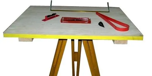
The errors may be grouped into the instrumental and personal errors. Instrumental Errors 1. The surface of plane table not…

The following four methods are available for carrying out plane table survey: 1. Radiation 2. Intersection 3. Traversing 4. Resection.…

The most commonly used plane table It consists of a well-seasoned wooden table Top mounted on a tripod. The table top can…
In compass survey chain or tape is used for linear measurement. If the surveying starts from a station, goes round…
A freely suspended and properly balanced magnetic needle is expected to show magnetic meridian.However, local objects like electric wires and objects…
The magnetic meridian and the true meridian may not coincide with each other in a place. The horizontal angle between…
To take a reading from a compass, the following temporary adjustments are required: (i) Centring: The compass should be fixed to…
Meet a creative publishing studio where AI writing, cover design and book formatting work together.